
Convenient Transport Links Can Make a Major Difference When Choosing Where to Buy
A house at the edge of a village can look wonderfully peaceful in photographs. The listing mentions a nearby highway, and a map shows what seems to be a road right beside the plot. Then a buyer arrives and discovers that the final stretch is a narrow track, difficult to navigate after rain. This is where careful research earns its keep. During an оценка на имот, cadastral information can establish a parcel’s recorded location and boundaries, while geographic maps help explain how that location connects to everyday travel. A good address is one thing, getting there comfortably throughout the year is another.
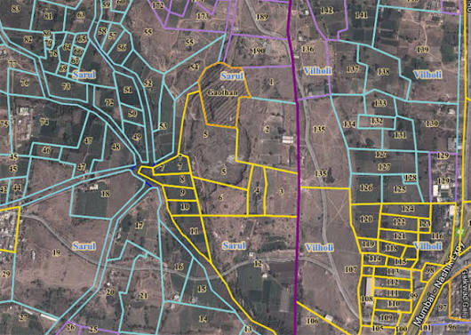
Road proximity is not the same as practical access. A property may sit close to a major route yet require a lengthy detour to reach an actual junction. Another might appear tucked away but enjoy a reliable connection to the town center. Looking at cadastral parcel outlines together with mapped roads helps buyers spot these differences before scheduling visits. It is worth checking the width and condition of local streets, whether vehicles can turn easily, and how routes behave in winter. Road surfaces may also change considerably between neighboring settlements. Importantly, a line on a map does not prove a legal right of access, which must be checked separately.
Public transport adds another layer to the picture, particularly for households that do not want every errand to depend on a car. A bus stop two streets away sounds convenient, but how often does a bus actually arrive? Does the service run on weekends, or only on school days? Route maps, published timetables, and local transport information can help answer those questions, though schedules and stops should be confirmed against current sources. For people commuting to Sofia, Plovdiv, Varna, or a smaller regional center, the difference between a dependable connection and an occasional service can shape the entire week. Travel times during peak hours deserve attention as well.
Travel convenience also depends on what lies between the property and the destination. A school might be close in a straight line, while the walking route involves an unsafe crossing or a long way around. Shops and clinics may be only a few kilometers away, but steep terrain or poor road surfaces can make the journey less straightforward. Comparing several locations with publicly available geographic information gives buyers a more realistic shortlist. An actual visit at a busy hour reveal details a digital map cannot, including traffic, noise, parking pressure, and whether the entrance is easy to find. Visiting more than once can reveal seasonal differences.
Before choosing between two similarly priced properties, bring the evidence together. Save the cadastral identifier, note possible road connections, compare realistic routes, and check the dates of map layers and transport schedules. Ask local authorities or qualified professionals about access rights and any planned road changes, rather than relying on assumptions. Ownership, encumbrances, detailed development plans known as PUP, and utility connections also need independent verification. An informed оценка на имот weighs daily travel alongside plot size and asking price. The winning location is not necessarily the one closest to a highway, but the one that makes ordinary journeys feel manageable for years to come.
…
